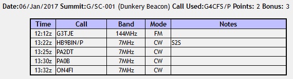
 Getting out on the hills has been very hit and miss over the past 5 months, mainly due to injury and other commitments. However, an opportunity came up for a final push before the ‘Winter Bonus’ season started. Obviously aiming to save all the 2+ pointers for the coming season I looked for a good cluster of 1 pointers that could be completed within the constraints of winter daylight hours. This was going to be a points grabber trip rather than a serious walking trip so the emphasis was on selecting hills with a quick turn-round.
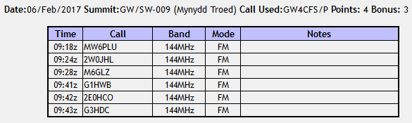
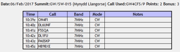
Six summits were selected from this list of hills I had completed last year and these were G/WB-020 Burton Hill, G/WB-023 Hegdon Hill, G/WB-022 Seager Hill, G/WB-024 Aconbury Hill, G/WB-021 Ruardean Hill and finally G/CE-001 Cleeve Hill. Checking the sunrise time for Burton Hill I had to leave home at 0500 and could spend a maximum of 30 minutes activating each hill in order to complete Cleeve Hill before sunset at 1600. This was also going to be the first outing of my new Sotabeams 40/30/20m linked dipole.
Equipment
FT-817 5 Watts, 4.2Ah LiFePO4, 40m/30m/20m linked dipole, 7m sotapole and a palm paddle, VX-8 plus RSS 2M dipole.
Burton Hill G/WB-020
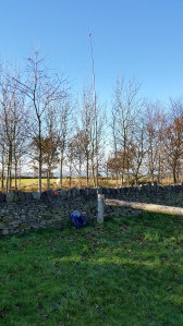
Having used Google Earth ‘flood tool’ I worked out that I could activate from near the transmitter site at the eastern end of the ridge which was well inside the AZ and only 5 minutes from the car. So parking at SO 415487 I set off along the level track over the first style and into the sheep pen.

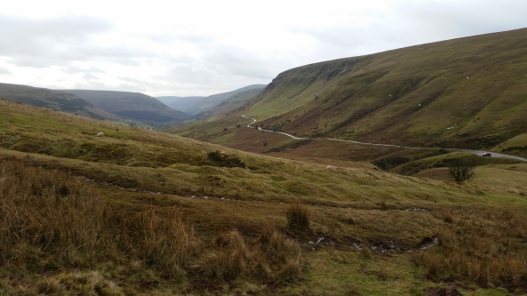
Path to sheep pen – mast visible on left
Self spotting on 7.031 MHz I quickly had 7 european stations in the log before all dried up. I noted on SOTAWatch that a VK was calling on 20m so a quick link and frequency change resulted in nothing but back ground hiss, shame would have been a great start to the day! Packing up I arrived back to the car 30 minutes after having left.

Hegdon Hill G/WB-023
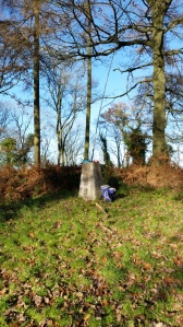
This hill is a ‘drive-on’ as the main road passes through the AZ and last year I had activated it as a last-minute add-on after a long day out from the grass verge. So this time I wanted to actually operate from the trig itself which require all of a 2 minutes walk through a field! Parking at SO 584538 I passed through the gate and walked along the right hand edge of the field to the trig.

Self Spotting on 7-cw I had a good steady flow of 10 european contacts over the next 17 minutes. For once the radio conditions were good and it seemed as though I was in for a good radio day. Once back at the car it was time for breakfast – total activation time 27 minutes.

Seager Hill G/WB-022
The next stop was Seager Hill, this is a short walk again from the car to the top of a long ridge within the AZ. Parking at SO 622379 there is a short, sign posted, path up through the trees to the ridge. The way ahead was a lot easier than last year as the trees had lost most of their foliage.
Self spotting for 7-cw brought in a very weak and unfortunately unworkable Jan OK2PDT. This was a shame because Jan had managed to work me on every hill so far. A little more calling brought 4 stations quickly into the log and qualified the hill but more importantly a strong Jan came through at the end for a good solid QSO and 3 out of 3 hills completed for him.
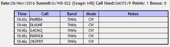 Carefully making my way back down the slippery muddy slope, I got back to the car 25 minutes after leaving it with 5 stations in the log before the band went quiet. So far all the contacts had been european except for David G4CMQ who made the journey from Ipswich with a 599/579 exchange from this hill.
Aconbury Hill G/WB-024
This is a favourite hill of mine with its gentle path up through the woods to the trip point in the middle of an Iron Age Hillfort. As an academic archaeologist I always feel a connection with these old places of habitation. It was also going to be the only ‘proper’ walk of the day. Parking at SO 506325 I set off along the path for a hundred metres to the gate on the left. From here follow the straight footpath to the very top of the hill and turn right at the T junction. The trig point is just up on the left side on a raised grass mound.
 Sticking to 7Mhz CW I quickly had a good pile-up going and logged 12 stations in 10 minutes including 2 more UK stations and, not surprisingly, Jan OK2PDT for hill number 4. On this hill band conditions seemed at their best all day with most incoming reports being 579 – 599. Adding to the good radio conditions the weather was playing ball today with a clear blue sky and a warming sun making for a very pleasant walk back to the car.
 Once back at the car (total time 45 minutes) I had plenty of time for a sandwich and some more coffee. With only two drive-on hills left to complete the 6 hill day I was more than happy to be well ahead of schedule as this would mean I missed the rush-hour chaos of the A34/M3 interchange later that afternoon on the way home.
Ruardean Hill G/WB-021
Last year I activated this hill from the Fields of the sports club, but this time I found a better location. From the village green head down Spout Lane towards the Pan Tod Beacon to a small parking area adjacent to the line of large boulders SO 634169. A timber gate next to the dry stone wall makes an ideal mast support whilst the wall itself acts as a desk for the rig.
 Self spotting for 7-cw quickly brought in its usual string of QSO’s – this time I managed 8 european contacts including, of course, Jan before all went quiet again. I might add that Jan was not the only one to get multiple contacts with me today, there were several regular callsigns appearing in the log though not all on every hill.
 The short walk back to the car concluded a 20 minute activation and now it was off to the final destination for the day.
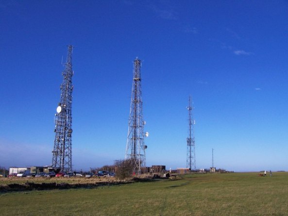
Cleeve Hill G/CE-001
This hill was added to the itinerary as it is a drive-on and en route home to Southampton. So after an hours drive from Ruardean Hill I pulled up into the car park on top of Cleeve Common adjacent to the transmitter tower complex SO 994248.
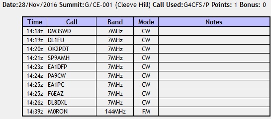
For this final activation I kept to the same procedure and opened up on 7-cw. Very quickly I had 9 stations in the log in 8 minutes all with very good signal reports. The bands had played well all day with a good skip into Europe from 0800 this morning till now. No prizes for guessing that Jan OK2PDT managed a QSO with me to complete 6 out of 6 hills today – always nice when you can do that.
 The activation was almost complete with just one thing left to do. I knew from past experience that there is good 2-fm monitoring carried out in this area by a few keen SOTA chasers in and around Cheltenham and Gloucester. So a quick call was made on S20 and immediately taken up by Andy M0RON, a callsign I did not recognise. The reason for this was made very clear during the next over. Last year I worked M6YAO for his first ever SOTA contact and I recall explaining what SOTA was all about. Earlier this year I worked 2E0PCP twice during my Welsh Marches Tour and now I had worked M0RON – all the same person at each stage of his progression through the UK amateur licensing system.
I said in the preamble that I would be using my new Sotabeams 40/30/20m linked dipole for the first time. Well I am not in a position for report how it performed as a radiator due to no comparative aerial. However, I did have a concern when I first received it in the post. The wire used for the actual dipole is very thin and I questioned in my own mind whether it would withstand the punishment of constant use in adverse conditions on SOTA activations. Compared to my old 60/40/20m linked dipole it was obviously shorter which made it easier to find space to erect it. I managed 120 activations with the old linked dipole with just one minor repair. The test of the new Sotabeams linked dipole will be time itself. Personally I don’t think it will last as well but I could be pleasantly surprised.
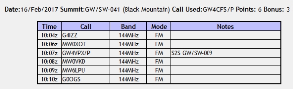
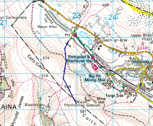
 Last time I walked up Black Mountain it was the day after Storm Henry had battered the UK and it was a wild ride to the top. I remember having to drop to my knees each time a gust came through otherwise I would be blown over! As a result I didn’t enjoy the trip and spent very little time on the summit. So I wanted to return in decent weather and have a more enjoyable journey. My second target of the day, Coity Mountain, was also visited last year. On that occasion I went up from the Big Pit side which is an awful route through the remain of the more working. So this time I approached from start point.
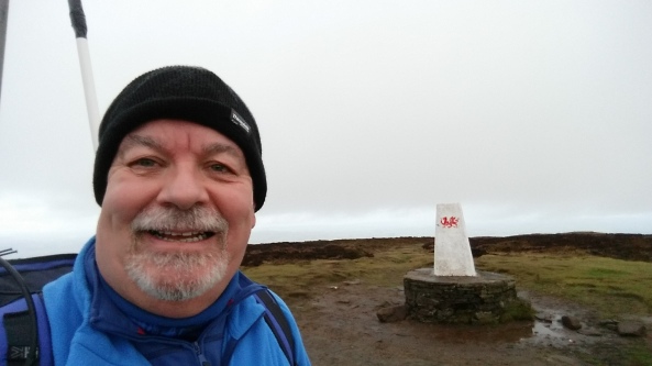


 The cloud had started to descend by now so I packed up and headed off back along the ridge to the top of the track then reversed my outbound track back to the car. Walk up to High Willhays via Yes Tor including chat 1 hour 30 minutes, time on summit 30 minutes, time back to the car 50 minutes.


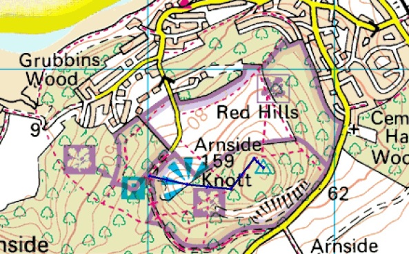
 Today we were going to Keswick for an evening show at the Theatre by the Lake. As a result are plan was to spend the day around Kendal relaxing. This meant the chance for another activation first thing in the morning. The target for today was Arnside Knott which was about 25 minutes drive from the hotel. Leaving the hotel at 7.30am I headed south on the A6 for Arnside and then took the road up to the National Trust Car Park, sign posted ‘The Knott’ (SD 449774).